- ~ Home
- ~ Vía de la Plata (The Silver Way)
Jump to Vía de la Plata Stages
The Vía de la Plata
The "Silver Way"
Last updated:
The Vía de la Plata, or the Ruta de la Plata, is one of the longest pilgrimage routes to Santiago de Compostela, at approximately 1000 km, (620 miles). It is a solitary and deeply historic walk. This route was used for the movement of goods and conquering armies even before the Romans built this paved road. It extends from the southwestern reaches of the Iberian peninsula to its northern shores.
"I’m never less at leisure than when at leisure, or less alone than when alone." ~ Scipio Africanus (236 BCE – 183 BCE), famous Roman General
🙋♀️ Why Trust Us at the Pilgrimage Traveler?

We’re not a travel agency ~ we’re fellow pilgrims! (See About Us)
We've trekked Pilgrimage Routes Across Europe since 2014!
💬 We’ve:
- Gotten lost so you don’t have to. 😉
- Followed waymarks in the glowing sunlight, the pouring rain and by moonlight. ☀️🌧️🌙
- Slept in albergues, hostels & casa rurals. Ate and drank in cafés along the way. 🛌 😴
- Created comprehensive and downloadable GPS maps and eBook Guides, full of must-have information based on real pilgrimage travels. 🧭 🗺️
- Shared our complete journeys, step by step to help YOU plan your ultimate pilgrimage and walk with your own Heart and Soul. 💙✨
Every detail is from our own experiences. Just fellow pilgrims sharing the Way. We have added a touch of spirituality, heartfelt insights and practical guidance from the road ~ offering a genuine connection to the spirit of pilgrimage. Tap into the wisdom of seasoned pilgrims!
Ultreia and Safe Pilgrimage Travels, Caminante! 💫 💚 🤍
What's in a Name?
The Vía de la Plata, or alternatively known by the locals as the Ruta de la Plata, actually begins in Sevilla (Seville) and ends at Astorga, (see our map below) for a total south to north distance of about 702 kilometers. It is in Astorga along the French Way where the pilgrim must walk west into Santiago along the Camino Francés, for the final 283 kilometers.

However, almost all route descriptions of the Vía de la Plata are referring to the alternative route from Granja de Moreruela, about 95 kilometers south of Astorga that heads in a more northwesterly, diagonal direction and onward through Ourense to Santiago de Compostela.
The route alternative from Granja de Moreruela is known as the Camino Sanabrés because it passes through the region of Sanabria. This is the route that most pilgrims take, including my group. There is only a few kilometers difference between the northerly route through Astorga to SdC and the Camino Sanabrés.
The Sanabrés is considered to be more scenic by most, but that is always a matter of preference. It is also debatable which route is more difficult as both routes travel through the Cantabrian mountains. There may be more consistent day-to-day elevation changes on the Sanabrés as it goes up and over the Montes de León, a section of the Cantabrian mountains.
Most certainly the Sanabrés sees fewer pilgrims, so that could also be a major factor in your decision-making, as it always is for me!
This camino is also known as the Camino Mozárabe, from Mozárab, a Spanish word derived from Arabic, meaning a Christian who lived in Spain during the Moorish rule. In the southern areas you will encounter waymarks, with Spanish and Arabic! How unique and interesting is that?
 Camino Mozárabe, Arabic Influence
Jump to Vía de la Plata Stages
El Camino Fonseca
And finally, to add to the confusion, but the most appropriate nomenclature for our walk, the Way between Salamanca and Santiago via the Camino Sanabrés is also known as the Camino Fonseca. This section was called the Camino Fonseca after Don Alonso de Fonseca y Acevedo III, a 16th century Archbishop of Santiago de Compostela.
Don Alonso de Fonseca also established colleges in both Santiago and Salamanca. He was educated at the University of Salamanca and is buried in the city. You can see a statue of him in the central courtyard of the Fonseca College University Library, adjacent to the Cathedral in Santiago!
While I have never heard this camino called the Camino Fonseca, perhaps it is more locally known as such. This Camino Fonseca, is the exact Camino that I chose to do, leading a small group of four, with our starting point in Salamanca.
Here is a photo of the four of us, by the famous Casa de las Conchas, adjacent to the cathedral, the official start of the Camino Fonseca in Salamanca. This huge shell marks the beginning!

🌍 Interactive Maps of the Camino Fonseca and the Entire Vía de la Plata Route
For various reasons, our group chose the Camino Fonseca, about one-half of the Ruta de la Plata, for a total of 492 kilometers (306 miles). This route is not a small feat as you shall see, if you read on! For us, it took 22 days, with 2 additional days for resting.
If you plan to walk the entire Vía de la Plata, you should plan on no fewer than 36 days, but only if you are a strong walker, you require no rest days and you are willing to do many days over 30 kilometers, and up to 38 on occasion. Otherwise, count on 40 or so days.
My intent is to one day return and complete the initial, more difficult and solitary portion from Sevilla to Salamanca, with its longer stages and less support services. We managed to keep our stages on the Camino from Salamanca to a less strenuous maximum of 32 km, and that was only one day. Our average was closer to 24 kilometers/day, a more manageable amount for our group.
Next are my interactive maps of the Camino Fonseca, from our GPS tracks, uploaded to Google Maps, with added features, like accommodations, eateries, water fountains, churches, etc.
The first interactive map is of the five days along the Vía de la Plata, from Salamanca to Granja de Moreruela. For a direct link to this map click here.
Next is the section of the Camino Fonseca along the Camino Sanabrés from Granja de Moreruela to Santiago de Compostela. For a direct link to this map click here.
And for your reference, here is a map of the entire Vía de la Plata, without features, again, from our GPS tracks The Camino Fonseca, which we walked is in blue.
To this map I have added sections and variations that we did not walk, in orange. These routes were created from the GPS tracks of others on Wikiloc, for the sake of clarity and information.
🌍 Map Like a Pro: Step-by-Step Guide to Using My Interactive Maps*
On a Laptop:
- Initial View: Click "View larger map" (upper-right).
- Re-access: Go to maps.google.com → "Saved" icon (left taskbar) → "Maps" (far right).
On a Mobile Device (Google Maps App - Recommended):
- Initial View: Tap "View larger map" (upper-right). May open in app or browser. Tap "Save" if your browser asks.
- Re-access: Open app → "You" or "Saved" (bottom taskbar) → scroll down → "Maps" (lower right).
On a Mobile Device (Browser):
- Initial View: Tap "View larger map" (upper-right). May open in app or browser. Tap "Save" if your browser asks.
- Re-access: Go to maps.google.com → dropdown under "Google Maps" → "My Maps."
💡 PRO TIP: Using My Interactive Google Map for GPS Navigation
- Jump to this page for downloading instructions.
- Jump to this page for uploading instructions.
*Note that my maps are not offline maps, but you will need to have a data plan for full functionality. However, you can use them offline. For instructions on how to do that, please click here.
Staying Connected with an eSIM:
If your wish is to stay connected and your mobile device supports eSIMs, it’s the easiest way to go. No need to swap physical SIM cards—you just activate a virtual one on your phone. eSIMs let you buy data plans online, so you're connected the moment you arrive. It is so simple!
Why I Recommend Roamless:
I personally use Roamless for its pay-as-you-go model and seamless global coverage. The inexpensive data never expires, making it perfect for long or multi-country trips. Activate it only once and never have to swap physical cards or eSIMs ever again, even when traveling to multiple countries across multiple dates. Find out more by clicking here and be an informed pilgrimage traveler!
Jump to Vía de la Plata Stages
History of the "Silver Way"
The translation of the Spanish word "Plata" means "Silver." However, this is a misnomer as there is nothing in the history of this route that has to do with the metal, silver. According to most online resources,* the name La Plata is derived from the Arabic word B´lata or Balata, which in Arabic means paved road.
While there is evidence that this long route was used even before the Romans by farmers moving domestic animals and goods, however, it wasn't until the Romans that an official road was established. Because of this, it has also been suggested that the name for this route was derived from the Latin word, "Lapidata” which also means stone road.

As we know, the Romans were marvelous engineers and built lasting roads and bridges sufficient to move their mighty armies, to conquer and maintain control of many lands. It was Scipio Africanus the Elder, from the above quote, who was a successful and celebrated Roman general that conquered Spain with meager forces. He is most famous for being ultimately responsible for defeating the Carthaginian general, Hannibal Barca, at the momentous Battle of Zama, in 202 BCE.
The first paved road, the Via de la Plata, was built by the Romans, extending from Cádiz on the south coast, through Seville (Hispalis) and Mérida (Emerita Augusta) to the gold mines in Las Médulas (region of Asturias) and to Asturica Augusta (Astorga), far to the north. Its purpose was clearly to move the gold metal, so perhaps it should have been called the "Gold Way," or the Vía del Oro!
Eventually other goods, metals and armies moved along the same Vía. Indeed, after the fall of the Roman empire, the Moors and the Spanish used this same route for the same purposes; for conquest and the movement of goods and services.
After the Spanish Reconquest from the Moors, this Way became an established pilgrimage route, increasing in popularity during the medieval times, so this Camino is also rich in medieval history. The tourist town of Puebla de Sanabria is a good place for a rest day, along the Sanabrés as you enjoy its medieval fortifications and wonderful vistas from the rampart walls.

To this day the Spanish modern highways, the A-66 and the N-630 parallel this route for the movement of people, goods and services. However surprisingly, today, only about 2% of all pilgrims to Santiago, walk the Silver Way, as the Pilgrim's Office Statistics in Santiago shows.
*Additional Resources:http://www.spainthenandnow.com/spanish-history/roman-roads-in-hispania
http://www.tarraconensis.com/hispania/viashispania.html
https://en.wikipedia.org/wiki/Roman_roads#Other_areas
** Please note that this photo is for the purpose of illustration only. I realize that this photo is not on the actual Vía de la Plata, but the Camino Sanabrés. The portion of the Vía de la Plata that we walked had no well-preserved section of Roman roads.
👣 Camino Sanabrés EBook:
Offline Guide with Bonus Route
~ Includes 4-5 additional days on the Vía de la Plata from Salamanca!
Walk smarter with our ad-free, beautifully formatted Camino Sanabrés eBook Guide, perfect for offline use ~ important in the mountainous and remote areas. Includes daily stage details, stunning photos, historical background and a BONUS digital guide on the Vía de la Plata from Salamanca, called the Camino Fonseca. This allows you the opportunity to add 4-5 more days to your Camino in the beginning.
Don't carry a hard copy guide book to increase your pack weight. Use our frequently updated digital guide on your next Camino instead!
📲 Instant download. 💸 Money-back guarantee. 🔄 Free updates for 1 year.
👉 Click here for more info or BUY NOW!
Jump to Vía de la Plata Stages
When to Go on the Vía de la Plata
In its 1000 kilometers, the Vía de la Plata travels through four distinct regions as it crosses from south to north, Andalucía, Extremadura, Castilla y León and finally, Galicia. You will encounter many different climates, depending on the altitude you are walking through, as well as the season.
It is generally advised to start this route in the spring months of March, April and May, or October in the fall. This strategy avoids Andalucía and Extremadura where the temps in the summer can easily exceed 100 degrees (38 Centigrade) and higher. Pilgrims have actually died of heat exposure in recent years, so the risk is not to be taken lightly.
The winter months in the southern regions can be quite mild but with a higher likelihood of rain. Many pilgrims prefer the solitude of walking in the winter months, however this does not apply to the already solitary Ruta de la Plata. Because of the paucity of pilgrims, many services and albergues close down from November to March, so plans to walk then must be thoroughly researched.
For me it seems optimal that you would start in early spring and as you walk northward, you would follow the warming of the respective regions, never getting too hot. However, we chose to start on October 2nd, giving us plenty of quite warm weather during the day, but with mostly cool nights.
For more excellent weather information regarding travel in Spain, click this link to aid you in your planning.
Jump to Vía de la Plata Stages
Landscape of the Vía de la Plata
The topography also varies immensely along the Ruta de la Plata. From the high plains of Andalucía in the south, with its Mediterranean scrub, olive trees and vineyards, to the endless pastureland of the Extremadura, the mixed forests of the higher altitude central mountains, and the endless fields of grain after Salamanca, the Vía de la Plata is ever changing on its course northward. High, hot and dry describe this landscape the best.

Once on the Camino Sanabrés, after the grain fields finally end, the majestic evergreen oak forests will surprise you as rainfall becomes more abundant.

And finally, in the higher, cooler and wetter climate of the mountains of Galicia, the pine forests and alpine landscapes predominate.

Which climate is the most enjoyable or the most conducive to walking, can only be decided by you, as all landscapes have something to offer, if respected for its uniqueness.
Jump to Vía de la Plata Stages
Waymarking
The waymarking, while less frequent than more traveled Caminos, is adequate, as described in the literature from Sevilla to Salamanca, and after Salamanca, from my own personal experience. There are unique markings as you go from municipality to municipality, as in all parts of Spain. There are also the ubiquitous yellow arrows.
In addition to the lovely pillars, like the one shown farther above with Arabic script, that appear between Salamanca and Granja de Moreruela, here is an extraordinary pillar that includes the pilgrim's staff and gourd. You will see several of these near Salamanca.

Below is common signage announcing the towns you are entering along the Way. This sign, at the church in the center of Granja de Moreruela, right beside the pilgrim's albergue, also announces the place of the bifurcation of the Caminos via Astorga and Ourense. There is also a sweet pilgrim's blessing.

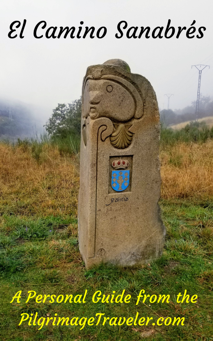
In the province of Castilla y León, these concrete waymarks predominate.
 Frequently Seen Mojón in Castilla y León
Upon entering the region of Galicia, very unique carved waymarks appear. Here is one below.

These incredible hand-carved waymarks are the hallmark of the province of Ourense, and are the handiwork of a local sculptor, Nicanor Carballo.
Each carved waymark in Galicia is totally unique as you can see from this one shown below. It must have taken Carballo a lot of time and effort to do this work, as you will see many of them in this area. It adds a wonderful element of mystique to this Camino. What a sweet addition these waymarks are!

Salutation
I hope this brief introduction has tempted you to consider this glorious walk! If so, may your own Camino on the Vía de la Plata be filled with both leisure and solitude. Ultreia!
Camino Fonseca Stages
~ Vía de la Plata Stages from Salamanca


~ Camino Sanabrés Stages


Please Consider Showing Your Support
Many readers contact me, Elle, to thank me for all the time and care that I have spent creating this informative website. If you have been truly blessed by my efforts, have not purchased an eBook, yet wish to contribute, I am exeedingly grateful. Thank you!
Search This Website:
The Pilgrimage Traveler Digital Guides
Our Guides Help You:
~ Know what to expect each day!
~ Locate historic sites along the Way!
~ Know where you are in your journey!
~ Discover a quote from the sages, for your daily reflection on the journey!
Click on a Photo Below to Get Your Copy.
A most popular alternative on the Central Route of the Camino Portugués!👇

The Portuguese Routes are rapidly gaining in popularity, especially the section from Lisbon! Plan to walk this one soon, before it is no longer a quiet experience!👇

Our most popular Portuguese guide! 👇

The most historic of the Portuguese Caminos ~ not to be missed!👇

The spiritual adventure of a lifetime, following in the footsteps of St. Teresa of Ávila!👇

The amazing mountain route alternative, the Camino Sanabrés, from Granja de Moreruela on the Vía de la Plata!👇
The most incredible mountain scenery on this camino from Leon to Oviedo!👇

The shortest of the caminos, but not easy!👇

The very first, Original Way from Oviedo to Santiago!👇

The pilgrimage to the "End of the World" ~ The perfect add-on to your camino!👇

All Banners, Amazon, Roamless and Booking.com links on this website are affiliate links. As an associate of these companies, the Pilgrimage Traveler website will earn from qualifying purchases when you click on these links. We have used and love all of our product recommendations and believe you will too! We sincerely thank you!

🙋♀️ Why Trust Us at the Pilgrimage Traveler?
We’re not a travel agency ~ we’re fellow pilgrims! (See About Us)
We've trekked Pilgrimage Routes Across Europe since 2014!
💬 We’ve:
- Gotten lost so you don’t have to. 😉
- Followed waymarks in the glowing sunlight, the pouring rain and by moonlight. ☀️🌧️🌙
- Slept in albergues, hostels & casa rurals. Ate and drank in cafés along the way. 🛌 😴
- Created comprehensive and downloadable GPS maps and eBook Guides, full of must-have information based on real pilgrimage travels. 🧭 🗺️
- Shared our complete journeys, step by step to help YOU plan your ultimate pilgrimage and walk with your own Heart and Soul. 💙✨
Every detail is from our own experiences. Just fellow pilgrims sharing the Way. We have added a touch of spirituality, heartfelt insights and practical guidance from the road ~ offering a genuine connection to the spirit of pilgrimage. Tap into the wisdom of seasoned pilgrims!
Ultreia and Safe Pilgrimage Travels, Caminante! 💫 💚 🤍
Follow Me on Pinterest:
Find the Pilgrimage Traveler on Facebook:
Shroud Yourself in Mystery, along the Via de Francesco!


Walk in the Footsteps of St. Francis, and Connect Deeply with the Saint and to Nature in the Marvelous Italian Countryside!
Need suggestions on what to pack for your next pilgrimage? Click Here or on the photo below!

Carbon Trekking Poles ~ My Favorites!

Carbon fiber construction (not aluminum) in a trekking pole makes them ultra lightweight. We like the Z-Pole style from Black Diamond so we can hide our poles in our pack from potential thieves before getting to our albergue! There are many to choose from! (See more of our gear recommendations! )
Gregory BackPack ~ My Favorite Brand


Do not forget your quick-dry microfiber towel!